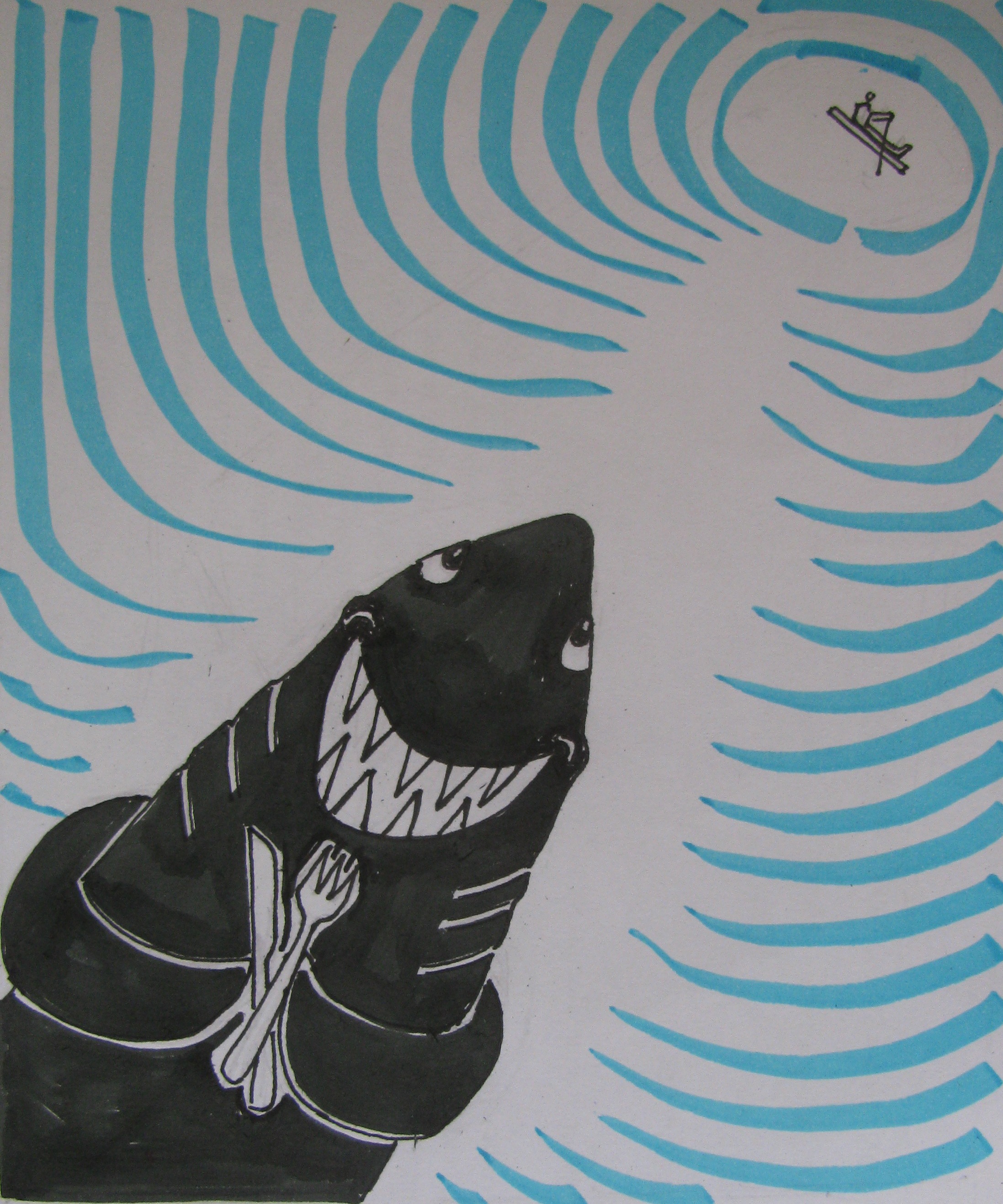
There goes lunch on a matchstick! (Illustration: Shyam G Menon)
I don’t know how this catamaran business got into my head.
I was quite terrestrial, mediocre swimmer; yet prone to trying things beyond me. That often meant embarrassment for oneself; entertainment for others. It didn’t take long to realize that the ultimate getaway was the sea. Its blue expanse is much bigger in size than land. And what better way to be at sea than in that tiniest of crafts – two or three logs stashed together; a catamaran.
Derived from the Tamil word, `kattumaram,’ the British fashioned it into catamaran and took the description overseas. The word was used to describe the multi-hull boats of South East Asia and Polynesia as well. No better than a big float and deeply enmeshed into man’s history of seafaring, the ancient craft was ubiquitous on the Kerala coast, where it was called kattamaram. Every time you saw a fisherman or two in the distance bobbing up and down in the waves as though they were sitting on the very ocean itself, you knew it was a catamaran below. The minimalist design, almost the lack of it, held a raw appeal. At the onset of monsoon local newspapers loved to publish the photograph of fishermen throwing themselves and their catamarans from a cliff top, into the sea.
I did not have to explain all this fascination to Jason, who had suddenly surfaced just outside the low boundary wall of the resort at Poovar near Thiruvananthapuram. I tracked his movement, shoulders and head visible above the wall and gauged from the smooth, mildly bobbing drift that he was standing on a canoe or something similar. He was hawking his day’s catch of a few small fish and oysters to the resorts bordering the estuary. I looked down from the wall and saw a frail catamaran under his feet. “ Can I sit on it?’’ I asked. He studied me for a second and simply said, “ take it. Go out into the estuary.’’ Then realizing he had dropped a bomb in my brain, he offered, “ don’t worry, I will swim alongside.’’ That presented a dilemma. For the journalist, no matter how badly he writes thinks himself as descended from the first revolutionary. The sahib-servant relation was abhorrent, unthinkable. This was just that – me on a catamaran, Jason in the water. Slavery!
“ No, no, that can’t be,’’ I said, sweating as a pantheon of ghosts, from Abraham Lincoln to Mahatma Gandhi, admonished me for even hearing the suggestion made. “ How could you?’’ they thundered. I cringed fearing their wrath.
But Jason’s problem was real – his catamaran of three thin logs could take only one person. Add a second and it would become a large overturned log; the sort ship wrecked sailors of yore clung to as they drifted to a remote Pacific island. Eventually, we decided – I would venture out into the estuary, Jason would instruct from land.
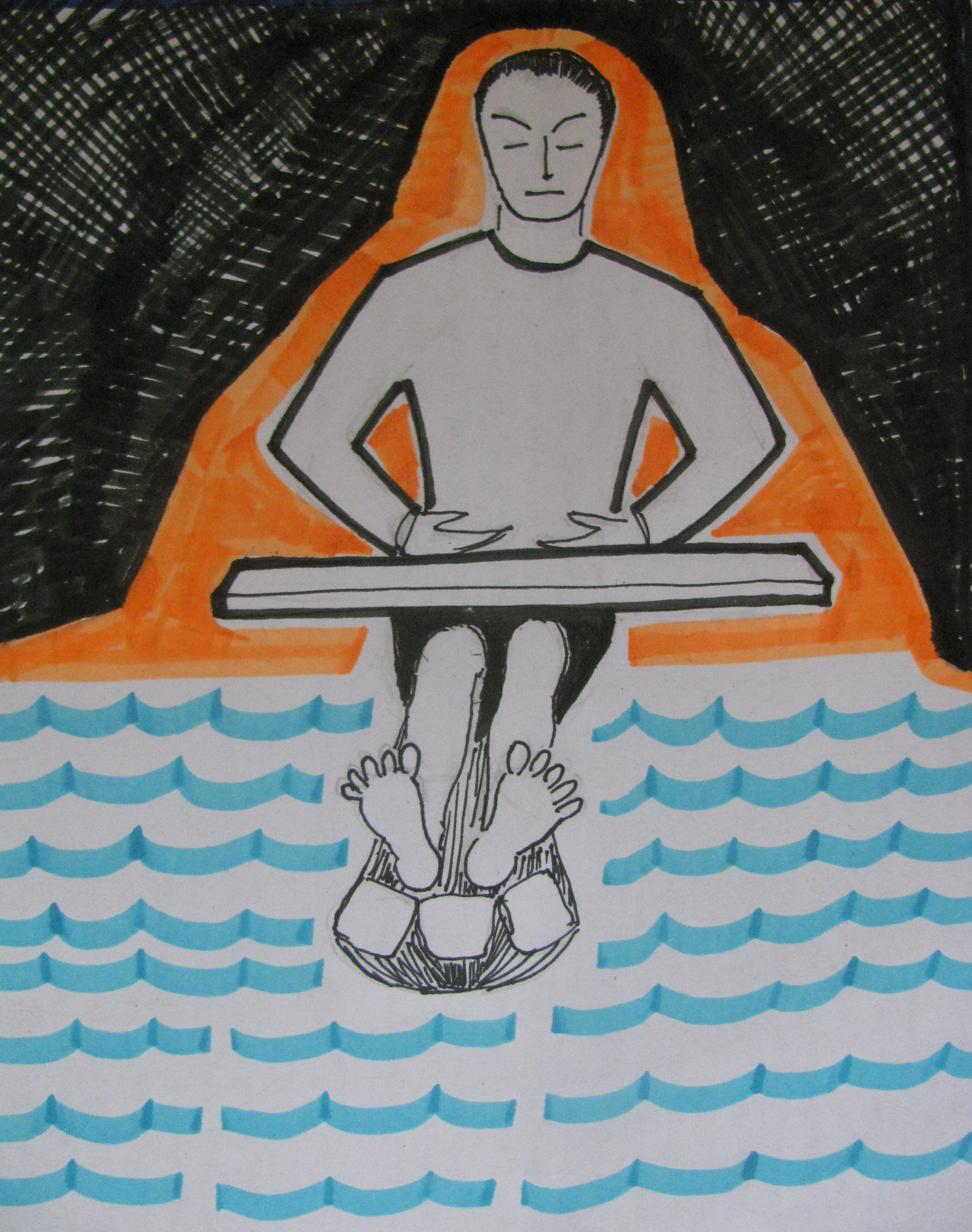
There were two possible postures on the frail craft. Jason preferred what I call the geisha pose, on your knees with legs tucked painfully under your butt. Given a painful middle aged knee, I couldn’t do that. So, I opted for the normal kayaking position. With one powerful push, Jason launched craft and me into the estuary. We shot out like an arrow into the silence of the deep. As the distance between me and land rose, my mind became a multiplex and playing on screen was the shark’s view from below – there goes lunch on a match stick. And as though to serve my imagined predators well, Jason’s energy transferred to the craft petered out and lunch-on-match stick slowed to a solemn halt. I looked into the water waiting for a shadow that would grow bigger and bigger till it erupts out of the water, the world goes black and Spielberg says, “ cut!’’ Jason must have sensed my nervousness. “ Take the oar and paddle,’’ he shouted from ashore. I took the oar – oar? Here I was, seated in the best kayaking position copied from TV and I had a five feet long wooden plank for oar. It was uniformly broad, thick and heavy. How the hell was Jason using this? He has to be a superman – I thought. Several strokes later, I was a panting mess beginning to question what I had got myself into.
This was my predicament somewhere in the middle of the estuary when the sound of outboard engines came from my right. Two boats were bearing down on me. Panic is not plain fright; it is the fright over what can be. In other words, the less you know the braver you seem, the more you know, the more panicky you get. And I knew what could happen (journalists always do). Those boats would generate waves high enough to upset me. Throw me into the water. Now technically speaking, the catamaran is deemed more stable at sea than the popular mono-hull boat. In fact when the multi-hull design emerged from Asia, western boat builders were both taken aback and too prejudiced to acknowledge its capabilities. It took many years for the catamaran to find acceptance, that too after several western interpretations that were no more than reinventing the Asian wheel. Today it is the stuff of power boat races. However, this debate was likely truer for the multi-hull. When you have two logs stashed together like the home made contraption I was balanced on, science was a luxury. Greater certainty seemed an unwanted exploration of marine life in the estuary. My paddling went askew. The tips of my `oar’ splashed frantically on the water’s surface hardly moving the craft, then from being wood, the oar metamorphosed to cast iron and my aching hands stopped paddling altogether. Resigned, I did the next best thing – kept the oar on my lap and sat there like a Buddha contemplating the mysteries of life. Both shores were far off, the bottom was far below, the sky was high above – so sat the hermit impervious to the outcome as two ferocious boats ploughed through the water at him. In reality the journalist was outthinking everybody else; TV crew interviews the eyewitness and he says, “ man, wasn’t that guy calm?’’
I sat there like a Buddha (Illustration: Shyam G Menon)
The first boat with its load of tourists whizzed by in front; the second followed on the other side. One swell, then the next – surrender worked, I rode both pretty well. My little matchstick was a toughie. It was to remind me later of a yacht I had boarded in Kochi. The Australian couple who owned it was sailing around the world. It was a beautiful, well appointed boat with a sense of security to it. I looked at the other yachts in the harbor, particularly a small one. “ That man should feel scared crossing a vast ocean,’’ I said. The husband narrowed his eyes. “ Look carefully. You see those hammer marks, like dents on the hull? That’s a home-made boat. He probably built it in his garage. Looks unsafe but when in trouble he would know it like the back of his palm. And he won’t be troubled often either for his boat is small. Unlike a big ship that has several stress points, this one will ride the waves like a matchbox; too small for the ocean to break.’’ At that moment in the estuary though, two swells tackled and the remaining ones dissipating into gentler bobs, I was just relief incarnate.
“ Keep going,’’ Jason shouted. But I had had enough even though I was slowly getting used to that oar. Direction now set toward Jason, I set off. Strangely even as I moved toward him, he drifted off to my left. The current was carrying me in a straight-right direction; like a general at a military parade with everything going past. The guard of honor – by now a couple of idle watchmen from the nearby resorts had also joined Jason – stared open mouthed at this demonstration of paddling skills. The battle now was to stop the drift, which I did by somehow heading for a resort’s wharf. Except that the current carried me under it; I was now safely lodged among a dozen wooden pillars that supported the structure. “ Hello…Sir?’’ If it was the Buddha garb in deep waters, I now responded to Jason with the air of an accomplished engineer, “ doesn’t anyone maintain these things? They look rather worn out underneath.’’ It struck me then that I had said the obvious and the best thing to do, was get out. But before that vanity struck. I glanced out to see if my antics were causing general alarm. My cousin Rajeev appeared settled into a hammock, reading a book. His mother, sister and family were chatting. Only Jason, watchmen and journalist seemed involved. Good. I nudged the craft inelegantly out from its refuge. And so, the greatest catamaran journey of all time ended with an emergence from under the wharf and on to Jason’s side.
He reluctantly accepted fifty rupees; lingered to finish a smoke with the watchmen and then neatly paddled off to his fishing village nearby. On the estuary, Jason looked like a monk with divine powers, seated on water and using mere will power to navigate. The whole thing worked like a well oiled piece of machinery – his effortless paddling, comfortable position and the catamaran, skimming along on the surface of the estuary. It could have made for a movie: Flying Jason; Hidden Catamaran – Ang Lee’s missed opportunity. Jason didn’t look back. I stood there watching him; the watchmen stood there looking at me. The British adventurer and buccaneer, William Dampier, is considered the first westerner to report on the `kattumaram’ of the Coramandel coast in the 1690s. “ They call them catamarans. These are but one log or two, sometimes of a sort of light wood….so small, that they carry but one man, whose legs and breaches are always in the water,’’ he had written. Dampier circumnavigated the globe thrice.
Pretty big connections for one really small craft, I say.
(The author, Shyam G Menon, is a freelance journalist based in Mumbai)